
As I wrote in my last post, these three hikes would be our initial opportunity to participate in the Citizen Science program, collecting data on the Mountain Goat and Bighorn Sheep populations in Glacier National Park. Any guesses what we found? Read on, dear friend, read on!
First destination: Apikuni Falls. Not only is there a debate on how Apikuni (or Appekunny) Falls is spelled, but also of its meaning, either "white-spotted robe" or "scabby robe". The white man who earned the Indian name of Apikuni (James Willard Schultz) married into the Blackfeet tribe and lived with them for many years. "Scabby robe" refers to one who is badly tanned with many hard spots.


As you walk the mile to the Falls, the trail transitions through meadow, forest and finally a rocky outcropping which grants your first view of the 100-foot waterfall. I love how the water falls directly off this rock shelf.

At the waterfall, we checked the Avenza Map app on my phone, which showed the goat observation point (a red dot) some distance to the right of us (a blue dot). It seemed simple enough, until we looked to the right. No discernible trail. Rocky scree with questionable footing. And steep. Hmm. Not ones to give up easily, we began the scramble. Within 10 minutes, we concluded this effort fell into the "not a good decision" category. Clambering up is one thing - how would we get down? And we had barely moved the blue dot any closer to the red dot! Volunteering has its limits, especially when life-endangering!
We settled for enjoying the mist from the Falls, and I felt I could spare a few minutes to shoot some flowers since we had budgeted an hour for goat observations.
Check out the slow motion of the falls.

James Schultz (Apikuni) was a noted author, explorer, guide, fur trader and historian of the Blackfoot Indians. Schultz wrote articles about the Glacier area for a new magazine called Forest and Stream. Its editor, George Bird Grinnell, was so taken by Schultz's description of the land that he paid a visit to the mountains in 1885. Grinnell was so inspired by what he saw that he spent the next two decades working to establish Glacier as the 10th national park.
Glacier National Park is beautiful now; I can only imagine how it was then!!!
On the way back, the higher elevation provided an even more expansive view of Many Glacier Valley.


The first mile of this 8.6 mile round trip is STEEP, a preface to the total elevation gain of 2,400 feet. Thankfully, the expansive meadows with a wide assortment of wildflowers were enough to keep me distracted!


The trail was mostly forested until the last half hour. Given that we had started this hike at 11.45, we were grateful for the shade in the (Montana) heat of the day. As much as we would have liked to linger at Swiftcurrent Ridge Lake, the mosquitoes who favor the shade were prevalent. Best to keep moving!
From the lake, we climbed to the top of the ridge, and then the trail began to descend. Surveying the topography, it was clear we would have more climbing to reach Poia. We were starting to get hangry!!!
Around this point, we saw the only person we would see on the trail to Poia, an interesting contrast to the dozens of hikers we saw on Apikuni and the hundreds we would encounter on the final hike.
We left our fellow hiker in the dry streambed and climbed a rocky escarpment. We knew we were getting close to our destination when we passed the campground. We did not pause until we reached the goat observation point (the red dot!) Boy, was it worth it. Outstanding views!


We don't typically go "off trail", but the red dot required that we do so. It was clear others had done the same, as a fairly clear footpath led to the observation point. The opportunity to get the view above is one of the many benefits I am sure that will accumulate from this volunteer gig.
The breeze on this promontory kept things cool even though we were in full sun at 2.15 in the afternoon. We satisfied our hunger with snacks before we started our observations. Sadly, not a single goat or sheep in sight. In fact, no footed critters anywhere - not even the ubiquitous marmots or ground squirrels.
(We had seen several piles of bear scat along the trail, but no bear sightings either. I suspect any bear would have been resting in the shade!)
We kept ourselves cool with wet neckcloths, dunked in the lake and streams we would cross.

No one was in the campground as we passed back through; given the time of day, I suspect this particular site would be empty for the night. I must admit that annoyed me a bit. Most of our applications for back-country camping permits have been denied, so I just expect that most of the time the campgrounds should be full!!! Despite our frustration, we do plan to a future camping trip along this way - it's another route to access the Belly River area, one of our favorites (see these posts from last summer: Lost for Words, A Slice of Paradise, Up, Up and Away.)
By the time we reached our hotel for the night, we had been awake since 5 am, and had hiked 10.6 miles while climbing 3,100 feet. We were ready for some chow, an adult beverage and then, bed!
The next day, we took the time to enjoy a cooked breakfast before heading to the Iceberg Lake trailhead. (And if you are keeping score, it's still goats = 0.)
.jpg)

Both days, we entered Glacier National Park through the Many Glacier entrance. This is one of the few access points that does not require a vehicle reservation, so we were anticipating some traffic at the entry point. That was not the case, thankfully. In fact, the entry station was not even staffed!
Before we left home, I had spoken with a friend about a recent hike, and I was shocked to learn she had not been able to complete the hike due to snow. "Take your Traxx," she advised. We did, and wondered what lie ahead when we saw this sign at the trailhead. (Warning - hazardous snow and ice conditions exist 2.5 miles ahead on Iceberg/Ptarmigan Trail (right after Ptarmigan Falls)).
We chatted a bit with several of our fellow hikers; one noted that she had been here three weeks ago and the snow had been manageable. As it turned out, she was right. (And when we returned to the trailhead, someone had removed this warning sign!)
It was hard not to notice the dozens of people on this trail; a marked difference from near-total isolation on the Poia trail the day before. I suppose it's popular because it only climbs 1200 feet and round-trip distance is 9.6 miles. And did I mention the spectacular views?


.jpg)
The on-line guide to Glacier National Park trails noted that bears frequent the area, especially the segment before Ptarmigan Falls. We did not see any, but today's check shows that the trail beyond Ptarmigan has been closed off and on since July 17 due to grizzly bear activity. Glad we did this hike on July 13!
Check out the slow motion videos of Ptarmigan Falls.
Roughly three miles from the trailhead, we emerged from the forest and from this point we had our first good views of our destination. Looking toward the left, we could see a cirque with a couple of large snowfields lying on the cliff walls. In the basin just below those snowfields is Iceberg Lake. (Can you see Man Without Hat in the center right of the picture below?)


Shortly thereafter, the trail reached the bottom of Ptarmigan Wall and began heading in a west-southwesterly direction. The Wall, towering more than 1500 feet above the trail, is known as an arete, defined as a thin ridge of rock separating two valleys that have been carved by glaciers. In this case, the Ptarmigan Wall divides the Many Glacier Valley from the Belly River Valley.
For the last 20 minutes of the hike, the trail was snow-covered, but manageable. A trail crew was clearing the drainage channels to encourage water to run off the trail rather than in it! I asked about the footbridge installation, and was told it is in place. (Seasonal footbridges are exactly that - removed in the fall and installed in the spring.) Yay - otherwise, it would have been a cold crossing!
We arrived at the goat observation point (the red dot), which this time was just to the right of the trail. Within the first 10 minutes of setting up our spotting scope and pulling out the binoculars, we had locked on two goats!!!
(Many hikers asked what we saw, and we invested a fair amount of time explaining the Citizen Science program, and sharing our spotting scope so they could catch a glimpse of the horned creatures!)
Score: goats - 3!!! It was quite exciting, and a thrill to share the experience with others! With that done, we could focus on enjoying the scenery and the return hike!

Orange sticks marked the way to the lake, the first time we have ever seen that. I believe it is meant to protect the magnificent alpine wildflowers that will emerge as the snow recedes.


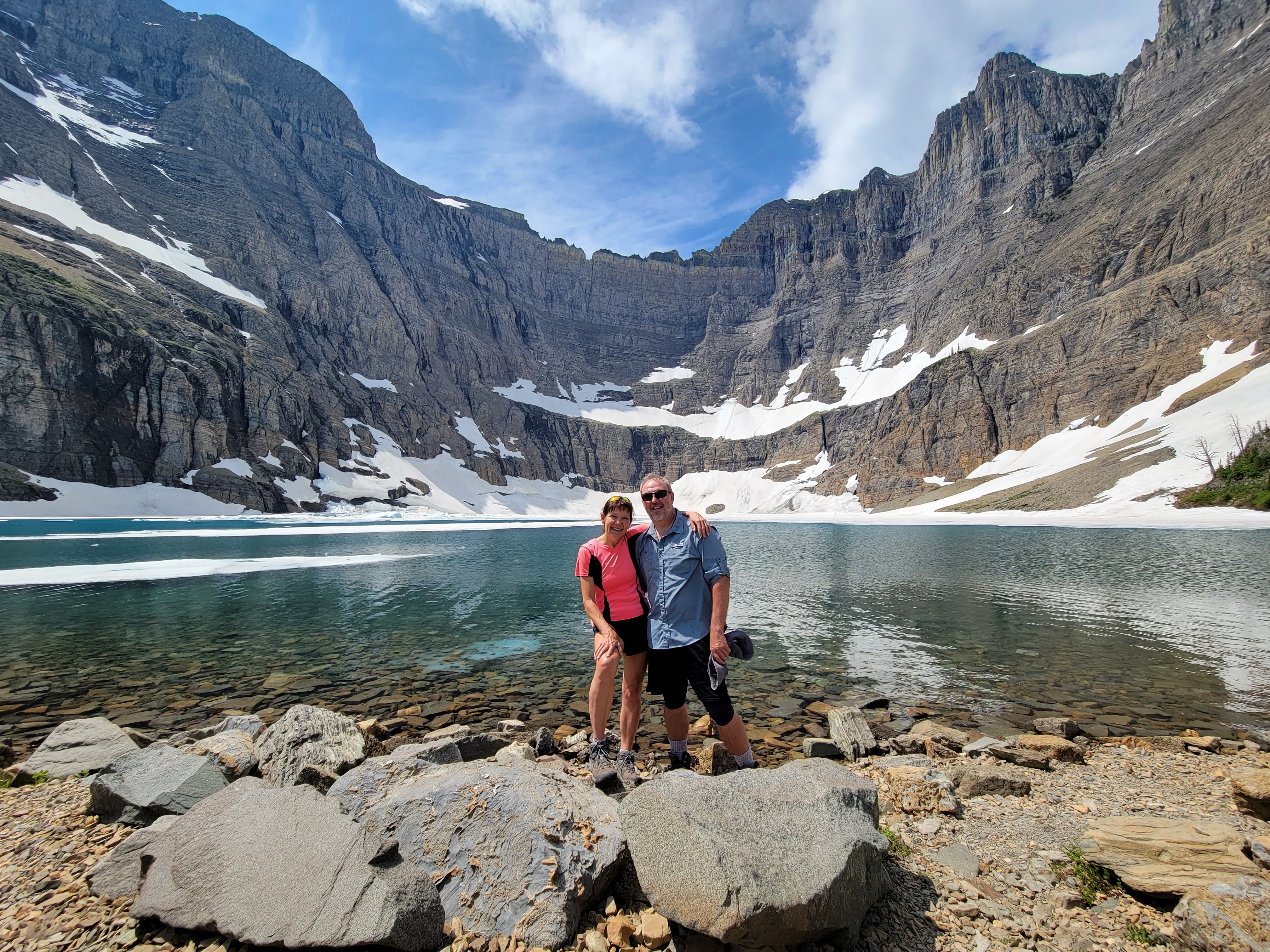
Sitting at an elevation of 6,094 feet, Iceberg Lake is in the shadow of mountains that tower 3,000 feet above. Hence, the lake receives little sunshine, thus allowing ice and snow to accumulate on the water and on the surrounding cliff walls. This didn't stop at least one visitor from going for a dip!

As we finished our break and snacks, threatening clouds had begun to gather, so we hoisted our backpacks and bade Iceberg farewell. We were surprised to see this small lake a short way down the trail - we must have been so anxious to reach the goat observation point that we didn't notice it!

I am not sure which mountain pops up in this picture below, but I love the contrast of the smoother edges and brown shades, compared to the knife-edge of the Wall.


It seemed quick when we arrived once again at the Falls. Despite the spots of rain that had been peppering us on the way down, we paused for a break.
With the prospect of a three-hour plus drive home, we did not tarry (except to take some flower photos!)


It had been a wonderful series of hikes, and I am grateful that we have the ability to enjoy Nature's bounty.

**I may be slow commenting this week, and Mosaic Monday will take a break on July 31st. See you again on August 7!

Welcome to Mosaic Monday, a weekly meme
where we get together to share our photo mosaics and collages.
Please include at least one photo mosaic/collage in your post.
The link will be open from 1 p.m. Sunday until 11 p.m. Tuesday (U.S. Mountain
time).
Remember to add the link to your Mosaic Monday post and not the one to your
blog.
Please link back to this post so that your readers will be able to visit and
enjoy more wonderful mosaics; taking the MM blog button from my sidebar is an
easy way to link back.
As host I will visit every participant and leave a comment so that you know I
stopped by.
Please try and visit as many other blogs as you can, especially those that join
in later, so that everyone's creativity can be appreciated fully.
Thank you for joining in today and sharing your mosaics with us.


.jpg)


